Three-dimensional point clouds represent one of the most powerful data formats driving the evolution of artificial intelligence and machine learning applications. These digital representations capture the spatial geometry of real-world objects and environments with remarkable precision, enabling machines to perceive and understand our three-dimensional world. From autonomous vehicles navigating city streets to robots performing complex manufacturing tasks, 3D point clouds provide the foundation for spatial intelligence in AI systems. As the demand for more sophisticated computer vision capabilities grows, effectively leveraging and annotating 3D point cloud data becomes crucial for AI model developers seeking to build robust, real-world applications.
What is a Point Cloud?
A point cloud is a collection of data points defined by their coordinates in a three-dimensional coordinate system. Each point represents a specific location in space, typically defined by X, Y, and Z coordinates that correspond to width, height, and depth, respectively. When viewed collectively, these individual points form a digital representation of the surface geometry of objects, structures, or entire environments. Point clouds can contain anywhere from thousands to millions of individual points, depending on the complexity of the scene being captured and the resolution requirements of the application.
2D vs 3D Point Cloud
Traditional 2D images capture only width and height, lacking the depth information needed to understand spatial relationships and real-world positioning.
3D point clouds add the critical third dimension, creating a complete volumetric view of the physical world. While a photograph shows what a car looks like, a 3D point cloud reveals its exact position, distance from other objects, and precise dimensions. This depth information enables AI models to understand when objects hide behind others and calculate accurate spatial measurements for real-world applications.
How Are 3D Point Clouds Generated?
The generation of 3D point clouds relies on various sensing technologies, each with unique advantages and limitations.
LiDAR
LiDAR (Light Detection and Ranging) systems represent one of the most popular methods, using laser pulses to measure distances to surrounding objects. These systems emit millions of laser beams per second, calculating distances based on the time it takes for light to return to the sensor, resulting in highly accurate point clouds with precise depth measurements.
Time-Of-Flight
Time-of-flight cameras use infrared light to measure distances, similar to LiDAR but typically at shorter ranges and lower resolutions. These sensors are commonly found in robotics and consumer devices and provide real-time depth sensing capabilities suitable for indoor applications and human-computer interaction.
Photogrammetry
Photogrammetry techniques reconstruct 3D point clouds from overlapping 2D photographs, using sophisticated algorithms to identify corresponding features across multiple images and triangulate their positions in space. This method can produce highly detailed point clouds using standard cameras but requires significant computational processing and careful image collection procedures.
Radar
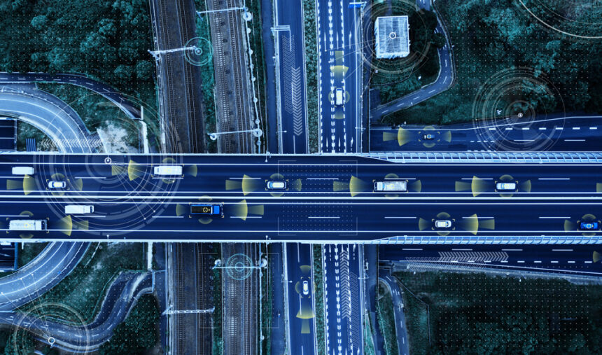
Radar systems generate 3D point clouds by transmitting radio waves and analyzing reflected signals to determine object positions and distances. Modern radar technology provides detailed 3D mapping capabilities with excellent performance in adverse weather conditions. In autonomous vehicles, radar offers crucial all-weather sensing that maintains reliable object detection even in fog, rain, or snow, where other sensors may be compromised.
Structured Light Scanning
Structured light scanning projects known patterns of light onto objects and analyzes the deformation of these patterns to calculate depth information. This technique provides high-resolution 3D point clouds with excellent accuracy for close-range applications. Structured light systems are commonly used in industrial quality control, facial recognition systems, and 3D modeling applications where precise surface detail is required.
Key Components of a 3D Point Cloud
3D Coordinates
The foundational element of any 3D point cloud consists of spatial coordinates, with each point defined by its precise X, Y, and Z position within a coordinate system. These coordinates form the geometric backbone that enables spatial analysis, distance calculations, and object recognition capabilities essential for AI applications.
Color Information
Color data, typically stored as RGB (red, green, blue) values for each point, provides visual context that significantly enhances object classification and scene understanding algorithms. This information enables AI models to leverage both geometric and visual features for more accurate analysis. Some specialized applications also capture additional spectral information beyond visible light for remote sensing and industrial inspection tasks.
Intensity
Intensity values measure the strength of the reflected signal used to capture each point, offering insights into surface properties such as reflectivity and material composition. This data proves valuable for distinguishing between different materials and surface types within the same scene, supporting applications like material classification and quality control.
Normal Vector
Normal vectors describe the orientation of surfaces at each point, indicating the direction perpendicular to the local surface. These vectors are essential for surface reconstruction, rendering applications, and understanding the geometric structure of objects within the point cloud, enabling more sophisticated 3D analysis capabilities.
Classification/Semantic Label
Semantic labels assign meaning to individual points or groups of points, categorizing them into predefined classes such as “ground,” “vegetation,” “building,” or “vehicle.” These labels are crucial for training supervised learning models and enable automated scene understanding and object recognition in AI applications.
Return Number
In multi-return LiDAR systems, return numbers indicate which reflection from a single laser pulse each point represents. This information helps distinguish between different layers of objects, such as tree canopies and ground surfaces, providing valuable context for environmental monitoring and forestry applications.
Timestamps
Temporal information records when each point was captured, enabling analysis of dynamic scenes and tracking of moving objects over time. Timestamps support applications such as traffic monitoring, crowd analysis, and change detection in environments where temporal relationships are critical for understanding scene dynamics.
Common Applications of 3D Point Cloud Annotation
Autonomous Vehicles
Autonomous vehicle development relies heavily on 3D point cloud annotation to create training datasets for perception systems. These annotations include precise labeling of vehicles, pedestrians, cyclists, traffic signs, road boundaries, and other critical elements within driving environments. The three-dimensional nature of point cloud data enables accurate distance estimation and spatial relationship understanding, which are essential for safe navigation decisions.
Robotics and Industrial Automation
Robotic systems use annotated 3D point clouds to understand their working environments and manipulate objects with precision. Applications include bin picking, quality inspection, assembly line automation, and navigation in complex industrial settings. Annotations typically focus on object boundaries, grasping points, and spatial relationships between components.
Healthcare and Medical Imaging
Medical applications leverage 3D point cloud annotation for surgical planning, prosthetic design, and anatomical analysis. Point clouds generated from CT scans, MRI data, or 3D body scanning enable precise measurements and treatment planning. Annotations may include organ boundaries, tissue classifications, and anatomical landmarks.
Architecture and Construction
Building information modeling and construction monitoring applications use annotated 3D point clouds to track project progress, identify structural elements, and ensure compliance with design specifications. Annotations typically include building components, measurements, and progress indicators that support project management and quality control.
Agriculture
Agricultural applications leverage 3D point cloud annotation for precision farming, crop monitoring, and yield optimization. Annotations include crop type classification, plant health assessment, canopy structure analysis, and growth stage identification. These detailed annotations enable AI systems to monitor crop development, detect disease patterns, estimate yields, and optimize irrigation and fertilization strategies for improved agricultural productivity.
Security and Surveillance
Security applications leverage annotated 3D point clouds for crowd monitoring, intrusion detection, and facility security. Annotations focus on human behavior analysis, object tracking, and anomaly detection within monitored environments.
Benefits and Limitations
Exceptional Accuracy and Detail
3D point cloud technology delivers millimeter-level precision by capturing fine details of objects and environments. This accuracy enables AI systems to make exact distance calculations and understand precise spatial relationships critical for applications like autonomous navigation and robotic manipulation.
Complete 360-Degree Perspective
Unlike 2D images that flatten three-dimensional information onto a single plane, point clouds provide a complete view of objects from all angles simultaneously. This comprehensive perspective allows AI models to understand the full geometric structure of scenes, including areas that might be hidden or obscured in traditional photography.
Weather-Independent Operation
Many point cloud generation methods operate independently of lighting conditions, maintaining consistent performance across diverse environmental scenarios. Whether in complete darkness, bright sunlight, or adverse weather conditions like fog and rain, these systems continue to capture reliable spatial data where traditional cameras might fail.
Rich Geometric Intelligence
The rich geometric information embedded within point clouds enables AI systems to perform complex spatial reasoning that would be impossible with 2D data alone. This capability supports sophisticated applications that require an understanding of volumetric relationships, surface orientations, and three-dimensional physical constraints.
High Computational Demands
Processing millions of data points in 3D point clouds demands substantial computational resources and specialized hardware, making real-time applications challenging. The sheer volume of data requires optimized algorithms and powerful processing capabilities.
Variable Data Quality
The accuracy and quality of point cloud data vary significantly depending on the capture method. LiDAR provides high precision but at a greater cost, while photogrammetry offers affordability with potential accuracy trade-offs.
Complex Annotation Requirements
Annotating 3D point cloud data from LiDAR and other sensors is exceptionally time-consuming and requires specialized annotation tools and domain expertise. Human annotators must navigate complex three-dimensional spaces, significantly increasing both time and costs compared to traditional 2D annotation tasks.
Discover iMerit’s 3D Point Cloud Annotation Solution
High-quality annotated 3D point cloud data serves as the foundation for successful AI and machine learning model development. iMerit’s comprehensive 3D point cloud annotation services combine advanced annotation tools with expert human intelligence to deliver the precise, scalable datasets your organization needs to achieve its AI goals. We specialize in handling complex annotation tasks across diverse industries, from autonomous vehicles to robotics and healthcare applications.
With iMerit’s cutting-edge, full-service 3D annotation platform, our team can build custom annotation processes for clients after calibrating quality and throughput requirements. Our quality assurance processes and project management expertise ensure that your annotated datasets meet the highest standards for training robust AI models.
Partner with iMerit to accelerate your AI development timeline while maintaining the data quality essential for successful model deployment. Contact our experts today to discuss how our 3D point cloud annotation services can support your next AI initiative!
Reference:
https://imerit.net/solutions/computer-vision/3d-point-cloud-annotation-services/
https://imerit.net/domains/autonomous-vehicles/
https://imerit.net/domains/agricultural-ai/